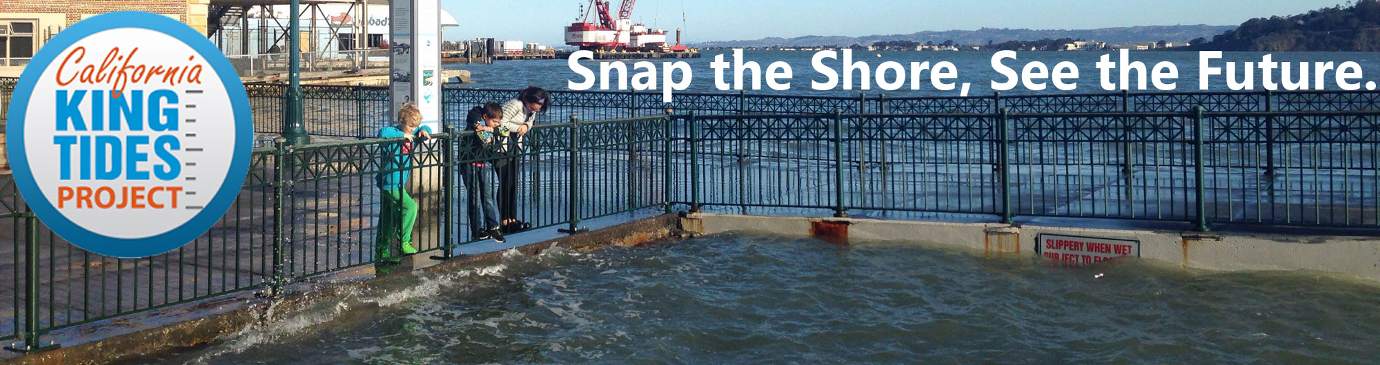
California King Tides Project
How to Participate |
King Tides Photo Gallery |
About King Tides |
Educator Resources
The most recent California King Tide Project dates were
November 15-17 and December 13-15, 2024.
Check back in summer for the next project dates.
Join #KingTides on social media:


Sign up to receive email about King Tides.
The California King Tides Project helps us visualize future sea level
by observing the highest tides of today. You can help by taking
and sharing photos of the shoreline during King Tides to create a record of changes to
our coast and estuaries.
Explore a map of
photos from recent King Tides.
Find out what time and how high
the King Tides will be near you. Learn how to participate by uploading your
photos via a web browser or with a free app. Your photos will be added to a map of this season's
King Tides photos. As always, please be cautious and respect the power of the ocean, and don't disturb shorebirds that
may be much farther upland than usual. Download a How to Participate flyer.
Join a King Tides event:
THE FOLLOWING EVENTS TOOK PLACE DURING THE MOST RECENT KING TIDES SEASON.
Observe and document King Tides on your own or join a group event.
If you would like to organize
an event, please email us at kingtides@coastal.ca.gov.
Each respective hosting organization is responsible for the following events. Please contact
them for further details.
Friday, November 15, 2024
King Tides High Tide Hike
Elkhorn Slough National Estuarine Research Reserve
1700 Elkhorn Road, Monterey County
Nov. 15, 9am
Presented by Elkhorn Slough Reserve.
Join an Elkhorn Slough Reserve naturalist to see a high king tide for yourself!
Together we'll learn what causes high tides, talk about why king tides are so interesting,
and take a hike to the Reserve's boardwalk to witness the event for ourselves. For more info,
go to elkhornslough/org/calendar
Saturday, November 16, 2024
King Tide Tour
Arcata Marsh & Wildlife Sanctuary
Arcata, Humboldt County
Nov. 16, 10-11:30am
Presented by Friends of the Arcata Marsh.
Join leaders Elliott Dabill and Barbara Reisman for a hike during one
of the November King Tides, the highest tides of the winter. Meet at
the first parking lot on I Street in from Samoa Boulevard (Rte. 255),
across from the "Green Wall." No RVSP is required for this free, all
ages interpretive tour along flat, gravel/paved paths, which occurs rain
or shine. This popular annual event attracts over 50 attendees! For questions,
email info@arcatamarshfriends.org.
King Tide Open House at Navarro-by-the-Sea
Captain Fletcher's Inn
Navarro Beach Road, Mendocino County
Nov. 16, 9am-noon
Presented by Navarro-by-the-Sea Center,
MendoParks, California State Parks.
The historic Captain Fletcher's Inn will be open for tours all morning while visitors take
a look at the king tide on nearby Navarro Beach. The fireplace will be going so visitors can
warm up, along with hot tea and light refreshments. Free admission. For more Info, contact
(707) 937-4700 or director@mendoparks.org.
King Tides Walk
Wetlands Edge Trail
2 Eucalyptus Drive, American Canyon, Napa County
Nov. 16, Noon-2pm
Presented by American Canyon Parks Foundation.
Become a community scientist for the day on this discovery walk. Help protect
our wetlands from the impacts of sea level rise by documenting what you see, learn
what causes the annual King Tide event and how conservation can help preserve the
wetlands from future sea level rise. Member of the Parks Foundation's Teen WILD volunteer
team will be on-site to lead short discovery activities. Bring your camera. The 1.5 mile
loop trail is a flat loose gravel trail appropriate for most walkers.
More info.
Napa River King Tide Paddle
5684 Lakeville Highway
Lakeville Landing, Petaluma, Sonoma County
Nov. 16, 1:45pm
Presented by Napa Valley Paddle.
Ride the biggest tide of the year from Petaluma to San Pablo Bay! Shuttle service
will be coordinated. Rent gear or bring your own. Register.
King Tide Ride to Ravenswood Preserve
Meet at Redwood City Public Library
1044 Middlefield Road, Redwood City, San Mateo County
Nov. 16, 11am-3pm
Presented by Silicon Valley Bicycle Coalition.
Join a beginner- and family-friendly group bike ride to Ravenswood Preserve to
witness the highest tides of the year! Register for the ride.
King Tides High Tide Hike
Elkhorn Slough National Estuarine Research Reserve
1700 Elkhorn Road, Monterey County
Nov. 16, 9:30am
Presented by Elkhorn Slough Reserve.
Join an Elkhorn Slough Reserve naturalist to see a high king tide for yourself!
Together we'll learn what causes high tides, talk about why king tides are so interesting,
and take a hike to the Reserve's boardwalk to witness the event for ourselves. For more info,
go to elkhornslough/org/calendar
King Tides: Java with a Lifeguard
Asilomar State Beach
Sunset Avenue, overlooking the north end of Asilomar State Beach, Pacific Grove, Monterey County
Nov. 16, 9-10:30am
Presented by Asilomar State Beach.
Learn all about King Tides -- what they are, why they happen, how they give us clues to our future,
and how to stay safe in and around the ocean! This is a free, family-friendly, drop-in event, open
to all. Grab a cuppa (joe, hot cocoa, tea) on us and observe this highest of high tides in good
company from a safe distance.
King Tide at Morro Bay
Morro Bay Museum of Natural History (car park), off Morro Bay State Park Road
Morro Bay State Park, San Luis Obispo County
Nov. 16, 9:20-10:30am
Presented by Cal Poly, San Luis Obispo College of Civil and Environmental Engineering and School of Marine Sciences and California State Parks.
Morro Bay is a unique estuary with a variety of environments, including pocket beaches,
rocky bluffs, sand dunes, salt marsh, freshwater creeks, and abundant wildlife. By
taking part in the California King Tide Project, your photos will help document high
water levels and improve understanding of how our coastal environments may change in
this beautiful location. During this event we invite everyone to take a snapshot of
King Tide water levels in Windy Cove and around the Morro Bay State Park Boardwalk,
so we can gain a fuller picture of how marine waters encroach upon different environments.
In Morro Bay, the peak of the King tide is predicted to occur between 9:45 and 10:05am.
If you have questions, email slee518@calpoly.edu.
King Tide at Avila Beach
Avila Beach Park, corner of San Juan and Front Streets
Avila Beach, San Luis Obispo County
Nov. 16, 8:30-9:30am
Presented by Cal Poly, San Luis Obispo College of Civil and Environmental Engineering and School of Marine Sciences and the Central Coast Aquarium.
Come to Avila Beach to document the highest tide by taking a snapshot of King
Tide water levels. Avila Beach has a varied environment which includes sandy
beach areas, an estuary, and bluffs. Join us to capture what King Tides look
like in these different areas and help build a library of images to paint a
clearer picture or what higher sea levels might mean for our local communities
and environment. If you have questions, email slee518@calpoly.edu.
King Tides at North Ponto
North Ponto in Carlsbad, San Diego County
Nov. 16, 8am
Presented by Surfrider San Diego County.
Join a Surfrider volunteer leader to observe the King Tides at North Ponto.
See how sea level rise will affect the beach, and learn about our work to preserve beaches
and the public's access to them. Also, discuss an early-stage managed retreat project to
save the beach at this location. Find out more and RSVP
here.
King Tides at South Cardiff/Seaside Reef
Seaside Reef in Encinitas, San Diego County
Nov. 16, 8am
Presented by Surfrider San Diego County.
Join a Surfrider volunteer leader to observe the King Tides at South Cardiff/Seaside Reef.
See how sea level rise will affect the beach, and learn about our work to preserve beaches
and the public's access to them. Find out more and RSVP
here.
King Tides at Solana Beach
Fletcher Cove in Solana Beach, San Diego County
Nov. 16, 8am
Presented by Surfrider San Diego County.
Join a Surfrider volunteer leader to observe the King Tides at Fletcher Cove.
See how sea level rise will affect the beach, and learn about our work to preserve beaches
and the public's access to them. Find out more and RSVP
here.
King Tides at Rose Creek Salt Marsh and Estuary
Mike Gotch Bridge
2600 N. Mission Bay Drive, San Diego
Nov. 16, 7:30–9am
Presented by Friends of Rose Creek.
Join Friends of Rose Creek for hot beverages and donuts at 7:30AM on the Mike Gotch Bridge
to photograph the king tides. For details, visit the website.
King Tide Hike
Tijuana Estuary
Imperial Beach, San Diego County
Nov. 16, 9-11am
Presented by Tijuana River National Estuarine Research Reserve and California State Parks, with support from the San Diego Natural History Museum and the San Diego Bird Alliance.
Join a morning hike during one of the November King Tides, the highest tides of
the winter. We are expecting an approximate 7 ft. high tide! You'll find out about how
the Research Reserve continuously measures water depth and is a sentinel site keeping
track of trends with a changing climate. You'll also learn about the award winning planning
to adapt to the impacts from riverine flooding and sea level rise. Please RSVP and see
more details on the Facebook page event.
Sunday, November 17, 2024
King Tides High Tide Hike
Elkhorn Slough National Estuarine Research Reserve
1700 Elkhorn Road, Monterey County
Nov. 17, 10am
Presented by Elkhorn Slough Reserve.
Join an Elkhorn Slough Reserve naturalist to see a high king tide for yourself!
Together we'll learn what causes high tides, talk about why king tides are so interesting,
and take a hike to the Reserve's boardwalk to witness the event for ourselves. For more info,
go to elkhornslough/org/calendar
King Tides at South Carlsbad
South Carlsbad State Park, Carlsbad, San Diego County
Nov. 17, 8:45am
Presented by Preserve Calavera and Batiquitos Lagoon Foundation
Observe and photograph the king tides at South Carlsbad Beach. Meet at the parking
lot at the South Carlsbad State Park just north of La Costa Avenue. We'll be near
the bathrooms and beach. Presenters will answer questions on climate change, sea
level rise and habitat impacts.
Friday, December 13, 2024
King Tides - The Future of our Coastline
Online
Dec. 13, 8:30-9:30am
Presented by California State Parks.
Join a live exploration of California's coastline to witness the powerful
King Tides. This special event takes you to 6 stunning state parks, showcasing
the potential impacts of sea level rise on our beloved coastal ecosystems. Witness
the high tide firsthand and join the conversation on climate resilience. Pre-registration is required.
For Teachers: You are welcome to share this webinar-styled program in your classroom.
If your students are watching on individual devices, please send this registration
link to your students. If each student is registered, it ensures that they will be
able to access this program. If students are not able to register, then you can simply
share the link you receive after registering. For more information,
visit the FAQ Page.
King Tides Pop Up
North End of Echo Avenue near Marina Village Flood Berm, Corte Madera, Marin County
Dec. 13, 9-10am
Presented by the Town of Corte Madera.
Join Town of Corte Madera staff to view the king tide from the flood berm protecting
the Marina Village neighborhood. Come out to observe the king tide and learn about the
recently completed Shoreline Adaptation Engagement Effort and next steps to protect this
area from flooding. For questions, email cmadapts@cortemadera.gov.
King Tides at the River Mouth
OB Dog Beach Paw Print
W Point Loma Blvd, San Diego
Dec. 13, 7:30-9am
Presented by San Diego Bird Alliance and San Diego Coastkeeper.
Take part in a guided bird walk at the San Diego River Mouth and help gather important
data by photographing the tide's reach. Your photos will contribute to vital research
on sea-level rise and coastal resilience. This free, family-friendly event is open to all
ages — come explore, learn, and make a difference!
Details and register.
Saturday, December 14, 2024
King Tide Day in San Rafael
711 Grand Avenue, San Rafael, Marin County
Dec. 14, 9am-noon
Presented by Canal Alliance,
Multicultural Center of Marin, UC Berkeley,
City of San Rafael,
Canal Arts, and the
Exploratorium.
Join your neighbors and local scientists to document the highest tides of
the year! Teams will use community science kits to explore how low-lying spots
along the waterfront are affected by king tides. Measure flooding and take pictures
alongside local experts. San Rafael is one of the Bay Area's most vulnerable cities
to sea level rise, and the information you collect will help our community prepare.
This even is free but please register in advance. Waterproof boots recommended!
Día de las Mareas Reales en San Rafael
711 Grand Ave, San Rafael
14 de Diciembre, 2024, 9am–12pm
Presentado por Canal Alliance, Multicultural Center of Marin, University of California Berkeley, the City of San Rafael, Canal Arts, and the Exploratorium.
Invitamos nuestros vecinos a reunirse durante las mareas más altas del año,
conocidas como Mareas Reales, para recolectar datos sobre el impacto de
inundaciones. Los participantes se dirigirán a la orilla de la bahía con
“kits de ciencia comunitaria” para medir los datos de inundaciones en
varios lugares. Los datos que se que recopilan ayudará a nuestra comunidad
a prepararse para las inundaciones. Por favor, registrarse para este evento
gratuita aquí. ¡Recomendamos que traigas botas impermeables!
Photography Workshop and King Tide Walk
Doug Siden Visitor Center at Crab Cove
1252 McKay Avenue, Alameda
Dec. 14, 10-11:30am
Presented by East Bay Regional Parks District and partners.
West End Arts District and Radium Presents are teaming up with East Bay Regional
Parks District, CASA, and Greenbelt Alliance to present a guided photography walk at
Crab Cove to capture the next King Tide. There will be an opportunity learn how to
capture key moments like the King Tides with an artistic lens, observe the King Tide
and hear how Alameda's shorelines must respond to rising seas in the future.
Get all the
details and register.
King Tides Walk
EV EcoCenter at the Palo Alto Baylands
2560 Embarcadero Rd, Palo Alto, Santa Clara County
Dec. 14, 9:30-11:30am
Presented by Environmental Volunteers.
Join Environmental Volunteers in a fun, interactive learning experience which will
teach you about what King Tides are and why they are exciting! The event will include
a brief hands-on science talk about the tides, and then a gentle walk through the
Baylands. Highest of the high tides is at 10:30am. Walks go RAIN or shine! Be prepared
for some wet trails and maybe some puddle-jumping. Learn more here. Participation is free, but space is
limited; please register through EventBrite (and sign up on the waitlist if tickets are full!
More will open up soon).
King Tides High Tide Hike
Elkhorn Slough National Estuarine Research Reserve
1700 Elkhorn Road, Monterey County
Dec. 14, 8:30am
Presented by Elkhorn Slough Reserve.
Join an Elkhorn Slough Reserve naturalist to see a high king tide for yourself!
Together we'll learn what causes high tides, talk about why king tides are so
interesting, and take a hike to the Reserve's boardwalk to witness the event for
ourselves. More info
2024 Winter Santa Monica King Tides Celebration
Santa Monica Beach
Meet at Heal the Bay Aquarium, 1600 Ocean Front Walk, Santa Monica, Los Angeles County
Dec. 14, 7-9am
Presented by Climate Action Santa Monica.
Experience one of the wonders of nature, the highest tides of the year! These high
tides give us a glimpse into the future of sea level rise and how these changes will affect our beach,
coastal infrastructure, and our community. This is a natural phenomenon which can be appreciated
for its subtlety and its potential intensity. It is an opportunity to connect with others
in a shared appreciation of the wonder of nature. At this event we will also collect images for
scientific documentation of the tides for the Coastal Commission.
Register online. For questions, contact
casmclimatecorps@gmail. Climate Action Santa Monica
is looking for volunteers to help people upload photos, lead groups, and help with registration.
Please reach out if you are interested!
Wandering the King Tides
Kendall-Frost Marsh
2055 Pacific Beach Drive, San Diego
Dec. 14, 6:30-10am
Presented by San Diego Bird Alliance and UC San Diego Natural Reserve System.
Every year we come together to document the highest tides of the year at Kendall-Frost
Marsh Reserve using Survey123, and this year, we're adding a creative twist!
We're inviting plein-air painters to capture the marsh as it transforms throughout
the day — every hour, leading up to the arrival of the King Tides. This event is open
to all ages, with no prior experience necessary for participants. Come enjoy nature,
witness the power of the tides, and be a part of this community effort! Spanish language
assistance will be available! More information and RSVP
Sunday, December 15, 2024
King Tide and Tea Bike Ride
Meet on the bike path behind Target in Eureka, Humboldt County
Dec. 15, 10:30am-12:30pm
Presented by Northcoast Environmental Center.
Join Northcoast Environmental Center and Coalition for Responsible Transportation Priorities
to check out the highest tides of the year and learn tips for biking around Humboldt Bay.
Free event.
King Tide Observation
Shell Beach
Shell Beach Parking Lot, Sonoma County
Dec. 15, 9-10am
Presented by Stewards of the Coast and Redwoods.
If you've been wondering what sea levels will look like as the climate changes, head to
the Sonoma Coast during a king tide. In the morning, you can observe the king tide (one of
the highest tides of the year). Experienced docents will be available to answer your questions.
Meet at the Shell Beach parking lot by 8am for a short, level walk to the bluffs. Wear weather
appropriate clothing including warm layers and comfortable shoes that can get muddy.
More info and register online. Return in the afternoon for tidepooling!
King Tides: A Royal Tide Watch Along the Embarcadero
Between Pier 3 and Pier 5 on the Bay side of Embarcadero
San Francisco
Dec. 15, 10-11am
Presented by Exploratorium and the Port of San Francisco.
Join the Exploratorium and Port of San Francisco staff along the Embarcadero to
observe, photograph, and discuss "Royal" Tides. These exceptionally high tides
will be "normal" tides of the future due to sea level rise. This free event will happen rain
or shine. Come find out what causes the tides, why we have King Tides this time of
year, and how the Port is supporting waterfront resilience. The high tide predicted
at Pier 41 that day is 7.21 feet at 10:35 a.m. For more information, contact
Lori Lambertson.
Museum entrance is not included. No reservations are required.
King Tides High Tide Hike
Elkhorn Slough National Estuarine Research Reserve
1700 Elkhorn Road, Monterey County
Dec. 15, 9:15am
Presented by Elkhorn Slough Reserve.
Join an Elkhorn Slough Reserve naturalist to see a high king tide for yourself!
Together we'll learn what causes high tides, talk about why king tides are so
interesting, and take a hike to the Reserve's boardwalk to witness the event for
ourselves. More info
Monday, January 13, 2025
King Tides Ventura
Ventura Pier, Ventura
Jan. 13, 8:45-11am
Presented by City of Ventura.
Explore the incredible King Tides and their impact on our coastline. This event will
include: Programs promoting ocean health, led by expert program managers; Connections
between nonprofits and the public sector working together for ocean health; Educational
Booths featuring fascinating insights into sea level rise; and Interactive Demonstrations
illustrating how tides shape our coastline. This free event is perfect for all ages. Come
explore, learn, and connect with your community while enjoying a morning by the ocean.
Please RSVP.
target="_blank">Please RSVP.