King Tides Home | How to Participate | King Tides Photo Gallery | Educator Resources
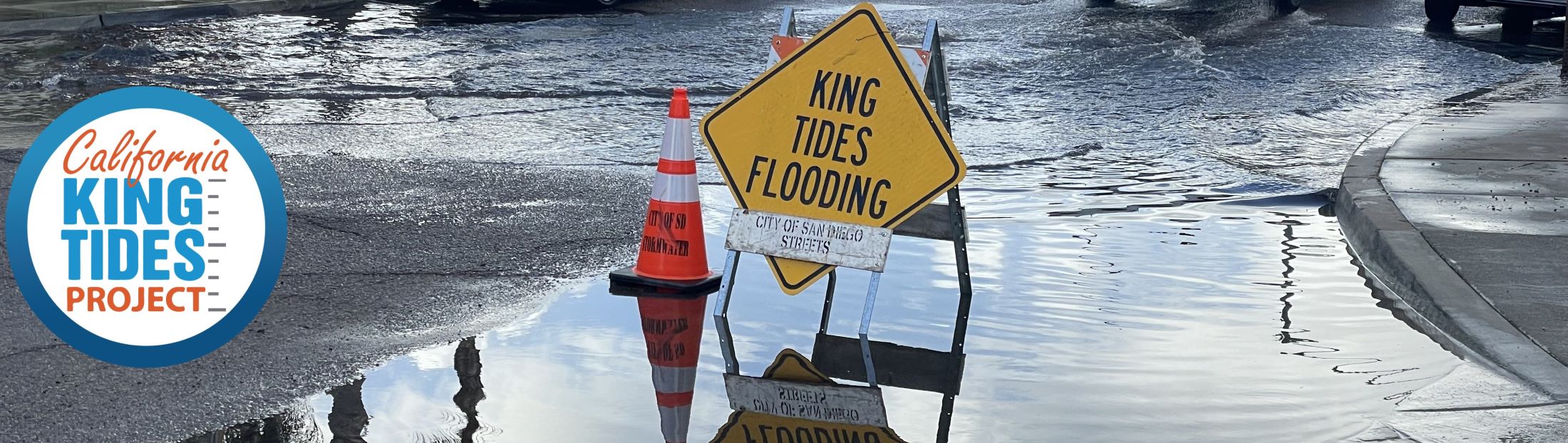
While the term "King Tide" isn't a scientific term, it is used to describe very high tides, caused when there is alignment of the gravitational pull between the sun, moon, and Earth, and when the moon is closest to the Earth. Around the New Year, the Earth is also closest to the sun, further increasing the gravitational pull on the ocean during California's winter season. When King Tides occur during floods or storms, water levels can rise even higher and have the potential to cause great damage to the coastline.
King Tides:
Watch a video from the Exploratorium explaining King Tides.
The sea level rise we're experiencing now and will experience in the future is caused by the growing concentration of carbon dioxide (CO2) in the atmosphere created when people burn fossil fuels like coal, oil, and gas. Carbon dioxide in our atmosphere acts like a blanket, trapping in heat that would otherwise escape, and when we burn fossil fuels, we're adding more carbon dioxide, "thickening the blanket" and warming the planet and ocean. Sea level is rising because land-based glaciers and ice sheets are melting into the ocean and also because water expands in volume when it warms. Increases in global sea levels have been recorded by tide gauges since the late 1800s, and more recent observations have been collected by NASA satellites. The amount of sea level rise we will ultimately experience will depend on how quickly we stop burning fossil fuels.
California will be greatly impacted by sea level rise. By 2050, the median sea level on our coast is expected to rise between .8 feet and 1.2 feet, and by 2100 to between 3.1 feet and 6.6 feet (State of California Sea-Level Rise Guidance, 2024 Update).
King Tides themselves are not related to climate change, but they allow us to experience what higher sea level will be like. King Tides are the highest high tides of the year—one to two feet higher than average high tides, which is a good approximation of how high we expect everyday tides to be over the next few decades due to human-caused sea level rise. When you observe the King Tides, imagine seeing these tides (and the associated flooded streets, beaches, and wetlands) every day. Understanding what a King Tide looks like today will help us plan for future sea level rise. Sharing your photos and talking about what you've noticed helps others understand that they're part of a community that cares about the climate crisis and wants to take action.
King Tides photos help:
Photos may be used in presentations, exhibitions, websites and publications on sea level rise impacts, coastal initiatives, and climate action. Photos may also be used by government agencies for research and planning to assess where the coastline is most vulnerable, and by scientists to better predict future sea level rise. Teachers and students use these photos to learn about our coastal geography and the impacts of climate change.
The California King Tides Project was launched in the winter of 2010/2011 by a partnership of state and federal agencies and non-profit organizations. The California project is now part of a global network of King Tides initiatives along both coasts of the US, Canada, Australia, New Zealand, Europe, and Asia. In California, partners include the California Coastal Commission, San Francisco Bay Conservation and Development Commission, California State Parks, San Francisco Estuary Partnership, Coravai LLC, California Coastkeeper Alliance, USC SeaGrant, California Department of Fish and Wildlife, Tijuana River National Estuarine Research Reserve, San Francisco Bay National Estuarine Research Reserve, Nature Collective, Tolowa Dee-ni' Nation, California State Parks, Friends of Five Creeks, Friends of Sausal Creek, Friends of Arcata Marsh, Friends of Rose Creek, Friends of Famosa Slough, Save The Bay, The Ocean Institute, Surfrider Foundation, Baylands Nature Interpretive Center, Big Break Regional Shoreline, Humboldt Baykeeper, San Mateo County Harbor District, San Mateo County, Elkhorn Slough National Estuarine Research Reserve, The Exploratorium, Port of San Francisco, Pacific Grove Museum of Natural History, City of Oceanside, City of Pismo Beach, City of Ventura, City of Arcata, Greenspace-The Cambria Land Trust, Green Foothills, Preserve Calavera, Golden Gate Audubon, Navarro-by-the-Sea Center, Sonoma Coast Surfrider, ECOSLO, Sanchez Art Center, Grassroots Ecology, Climate Action Santa Monica, San Diego Natural History Museum, Roundhouse Aquarium, Silicon Valley Bicycle Coalition, Sierra Club San Francisco Bay, Latino Outdoors North Coast, UC Scripps Coastal Reserve, San Diego Bird Alliance, Mendocino Land Trust, Lost Coast Getaways, Arriba South Coast, San Mateo Resource Conservation District, Morro Bay Natural History Museum, Cal Poly Center for Marine Sciences, City of Alameda, American Canyon Parks Foundation, Canal Alliance, City of San Rafael, Friends of China Camp, San Francisco Bay Wildlife Society, Environmental Volunteers.
Check out some of our neighbor King Tides Projects in Oregon, Washington, and Hawai'i.
Join #KingTides on social media:
![]()
![]()
![]()
kingtides@coastal.ca.gov